Data density is an important parameter in LiDAR survey. While a dense data captures the terrain better and helps in information extraction the time and resource requirement is high. The data density is decided depending the application for which the data are being collected. The data density mainly depends upon the parameters of sensor and platform e.g., flying height, velocity, scan angle, scan frequency, pulse firing rate, scanning pattern, acceleration and attitude variation of platform. Additionally, it also depends upon the ground geometry and reflectivity.
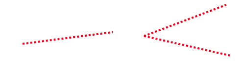
Figure 21: Scan definitions
Depending the sensor a scan could be of any of the two types as shown in Figure 21.
Considering the scan frequency is fsc the number of data points in one scan will be:

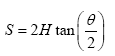
If the platform is at an altitude of H and scan angle is θ the swath S is given by:
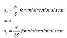
Thus the data density (points per unit length) across the track (i.e. in the direction of scan) is given by :
The data density along the track is variable for zig-zag scan and uniform for parallel line pattern. The maximum separation is given by:

Another approach to represent data density is as number of points in unit area. In this case the data density can be given by:

where v is the velocity of airborne platform and vS is the area covered in one second while F is the number data points generated in one second. In above it is assumed all fired pulses will result in a measurement.