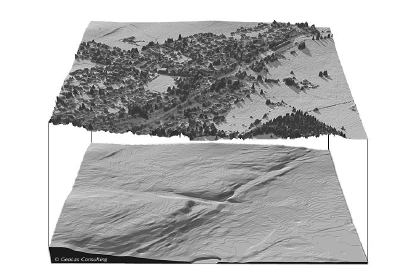
· LiDAR pulses are capable of passing through the small gaps in forest canopy. Thus data points will be available under the canopy of a tree. Algorithms are available which can separate the data points on trees and on the ground, thus producing a DEM of the forest floor (Figure 23). The forest floor DEM has applications in forest fire hazard zoning and disaster management
· As LiDAR data points are spread all over the canopy, models are being developed for estimation of biomass volume using LiDAR data.
· The information about percentage of points which penetrate the canopy of a tree can be related to the Leave Area Index (LAI)
Figure 23: LiDAR data of forest (top) and corresponding forest floor DEM (below)(Courtesy Geolas)