LiDAR data can be used for generating the maps of urban areas at large scale. LiDAR facilitates identification of buildings from the point cloud of data points, which are important for mapping, revenue estimation, and change detection studies. Drainage planning in urban areas needs accurate topographic data which are not possible to be generated in busy streets using conventional methods. The ability of LiDAR to collect data even in narrow and shadowy lanes in cities makes is ideal for this purpose. Accurate, dense and fast collection of topographic data can prove useful for variety of other GIS applications in urban areas, e.g. visualization, emergency route planning, etc
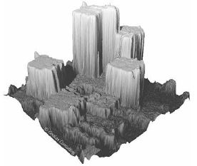
Figure 24: LiDAR data for a hotel (Courtesy Geolas)