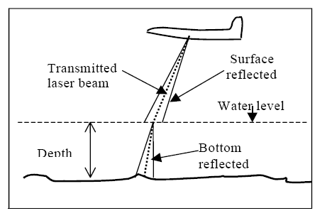
Most of the initial uses of LiDAR were for measuring water depth. Depending upon the clarity of the water LiDAR can measure depths from 0.9m to 40m with a vertical accuracy of ±15cm and horizontal accuracy of ±2.5m. As shown in Figure 5 a laser pulse is transmitted to the water surface where, through Fresnel reflection, a portion of the energy is returned to the airborne optical receiver, while the remainder of the pulse continues through the water column to the bottom and is subsequently reflected back to the receiver. The elapsed time between the received surface and bottom pulses allows determination of the water depth. The maximum depth penetration for a given laser system is obviously a function of water clarity and bottom reflection. Water turbidity plays the most significant role among those parameters. It has been noted that water penetration is generally equal to two to three times the Secchi depth. Furthermore, the bottom and surface signals should be clearly distinctive to compute the water depth. In the case of shallow depths these signals overlap making it impossible to determine the water depth.
Figure 5: Principle of Bathymetric LiDAR
The wavelength used in this case is blue or green as these can transmit in the waterbody thus maximizing the measurable depth by LiDAR.
A hybrid LiDAR system employs both infra-red and green laser (concentric). While the infra red laser is reflected from land or from the water surface the green wavelength proceeds to and gets reflected from the bottom of water body. This makes it possible to capture both land topography and water bed bathymetry simultaneously.