Journal of The Indian Society
of
Remote Sensing
Vol. 33 No. 2 June 2005
|
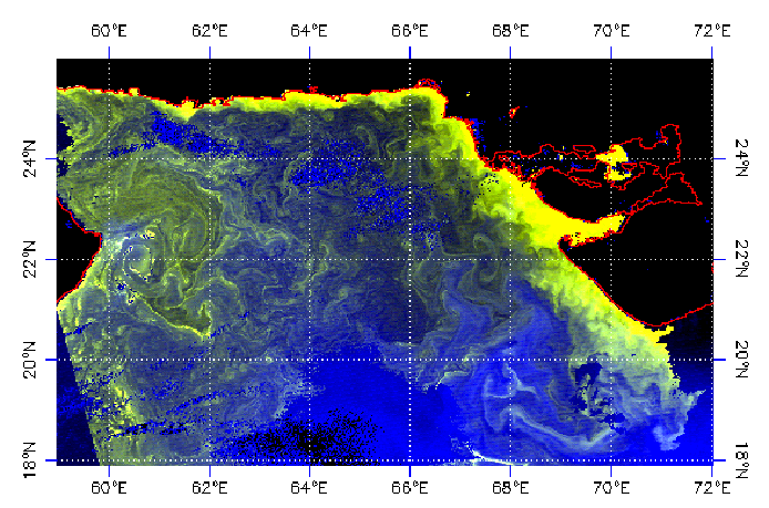 |
Cover Article:
Prakash Chauhan, P.V. Nagamani, H.U. Solanki and Shailesh
Nayak
Composite Image of chlorophyll and Sea Surface Temperature (SST) Using MODIS-AQUA
|
Sl. No. |
Authors |
Title of the Paper |
Page no |
|
Cover
Article |
|
1 |
Prakash Chauhan, P.V. Nagamani, H.U. Solanki,and Shailesh Nayak |
Composite
Image of chlorophyll and Sea Surface Temperature (SST) Using MODIS-AQUA |
177-180 |
|
|
|
2 |
S.S. Ray,
Anil Sood, Gargi Das, Sushma Panigrhy, P.K. Sharma and J.S. Parihar |
Use of GIS and Remote Sensing for Crop Diversification-A Case Study for
Punjab State |
181-188 |
|
3 |
P.S. Arun, R. Jana and M.S. Nathawat |
A Rulebase Physiographic Characterization of a Drought Prone Watershed
Applying Remote Sensing and GIS |
189-202 |
|
4 |
D.P. Sharma
and Leon Bren |
Effect of
Seasonal
Spectral
Variation
on
Land
Cover
Classification |
203-210 |
|
5 |
D. Singh,
I. Herlin, J.P. Berroir, S. Bouzidi |
An Approach to Estimate the Evapotranspiration Using NOAA/AVHRR Data |
211-218 |
|
Short note |
|
6 |
Pramod K. Singh,
B.K. Singh and Ajeet Singh |
Managing Tree Cover in Yamunanagar district of Haryana: A Remote Sensing
and GIS Approach |
219-226 |
|
7 |
Sudhir Mahajan and Panka Panwar |
Landuse changes in Ashwani khad watershed using GIS Techniques |
227-232 |
|
8 |
Amba Shetty,
Lakshman Nandagiri, Sangeeta Thokehom and Rajesh |
Land
Use
– Land
Cover
Mapping
using
Satellite
Data
for a
Forested
Watershed,
Udupi
District,
Karnataka
State, India |
233-238 |
|
9 |
Preeti C. Solanke, Rajeev Srivastava, Jagdish Prasad, M.S.S.
Nagaraju, R.K. Saxena and A.K |
Application of Remote Sensing and GIS in Watershed Characterization and
Management |
239-244 |
|
10 |
H.S. Negi, V.D.
Mishra
and
P. Mathur |
Change Detection Study for Snow Covered Mountains Using Remote
Sensing and Ground Based Measurements |
245-252 |
|
11 |
M. Shamsudheen, G. S. Dasog
and
N. B. Tejaswini |
Land Use / Land Cover Mapping
in
The Coastal Area
of
North Karnataka Using Remote Sensing Data |
253-257 |
Special Section:
ISRS National Symposium on “Advance in Remote Sensing Technology with Special
Emphasis on High Resolution Imager”
|
12. |
Sarvesh Palria, Akanksha Singh, J.R. Sharma, Suparn Pathak |
Habital Evaluation for Sarus Crane in Keoladeo National Park Using IRS
LISS III
and
PAN Merged Data and GIS |
259-266 |
|
13. |
K.S. Rao, Manisha G. Naidu, Jyoti Sakally and
Santosh Phalke |
Study of DEMs Derived from ERS-1/2 SAR and SRTM Data |
267-276 |
|
14. |
S.M. Moorthi,
Nitant Dube, D. Dhar, B. Kartikeyan and R. Ramakrishnan |
Resourcesat (IRS-P6) Value Added Data Products |
277-284 |
|
15. |
S.S. Randhawa, R.K. Sood, B.P. Rathore and A.V. Kulkarni |
Moraine – Dammed Lakes Study in Chenab and Satluj River Basins Using IRS
Data |
285-290 |
|
16. |
D.K. Rout, P.K. Parida and
G. Behera |
Man-made Disaster- A Case study of NALCO Ash-pond in the Angul District,
Orissa using Remote Sensing and GIS Tehnique |
291-295 |
Special Section:
“Modeling for Remote Sensing Applications in Agriculture”
|
17. |
V.K.
Sehgal
and C.V.S. Sastri |
Simulating
the Effect of Nitrogen Application on Wheat Yield by Linking Remotely
Sensed Measurements with WTGROWS Simulation Model |
297-306 |
|
18. |
R.P.
Singh,
V.K. Dadhwal, K.P. Singh, R.R. Navalgund, R.Sharma, G.D. Bairagi, S.A.
Raza and N.K. Sharma |
Retrieval
of Wheat Leaf Area Index Using Price Approach Based on Inversion of
Canopy Reflectance Model |
307-314 |
|
19. |
S.P. Vyas,
M.D. Steven and K.W. Jaggard |
Comparison
of ERS-SAR and SPOT Data for Sugar Beet Crop Cover Assessment |
315-322 |
|
20. |
Sasmita
Satapathy and V.K. Dadhwal |
Principal
Component Inversion Technique for the Retrieval of Leaf Area Index
|
323-330 |
|
21. |
B.K.
Bhattacharya and V.K. Dadhwal |
Land
Surface Temperature Retrieval and Its Validation Using NOAA AVHRR
Thermal Data |
331-338 |
|
22. |
V.N.
Sridhar, R.P. Singh, Anjum |
Crop
Polarisation Behavior Derived from Multi-Temporal ADEOS-POLDSER Data |
339-344 |
|
23. |
D.R.
Rajak, M.P. Oza, N. Bhagia and V.K.
Dadhwal |
Spectral
Wheat Growth Profile in Punjab using IRS |
345-352 |
|
24. |
Tara Sharma,
Jeff Carmichael and Brian Klinkenberg |
A Spatially
Explicit Modeling Approach to Explore Scenarios of Sustainable
Agriculture Futures |
353-363 |
 Back
to Main Page
Back
to Main Page